
Gemini Terrain+
A trusted, real‑time terrain modelling tool that helps you manage every phase of your construction projects.
Built to give you clear control of quantities, data, and design throughout your daily work in the field and office.
Clarity and control for every stage of your construction project.
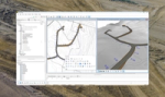
The Gemini Terrain+ module provides terrain modelling, road design, and quantity calculation functions in 3D. All model updates synchronize in real time across workflow stages, ensuring alignment of calculations and data.
During daily operations, the module enables continuous management of quantities, design updates, as-built documentation, and data sharing. It facilitates planning, engineering, supervision, and documentation processes, including for long road sections or variable terrain conditions.
The solution provides structured data flow, support for industry-standard formats, cloud-based access via Gemini Connected, and collaboration tools for team decision-making based on current project data. It includes customizable reporting, NVDB compliance verification, and a multi-user cloud environment for project-wide data consistency.
Products
Related products

Common questions about Gemini Terrain+
Find answers here
Because all updates happen in real time, your team always works from the latest model. This reduces the risk of outdated calculations or incorrect stakeout data being used on‑site.
Yes, the cloud environment supports multi-user access with shared project data across participants. This helps avoid conflicting versions and supports coordinated workflows.
It supports large-scale road projects with dynamic models, automatic profile updates, and tools that handle long or complex road alignments.
The software supports commonly used industry formats to enable data exchange between systems, specialists, and field tools. This supports interoperable workflows across project participants.